DALLAS — After sunshine and beautiful conditions across North Texas earlier in the week, severe weather entered North Texas on Friday afternoon.
Versión en Español: Sol para empezar la semana, pero tormentas para el fin de semana
Quick facts:
- Warm, breezy, and muggy through the weekend
- Higher storm chances return by Friday morning
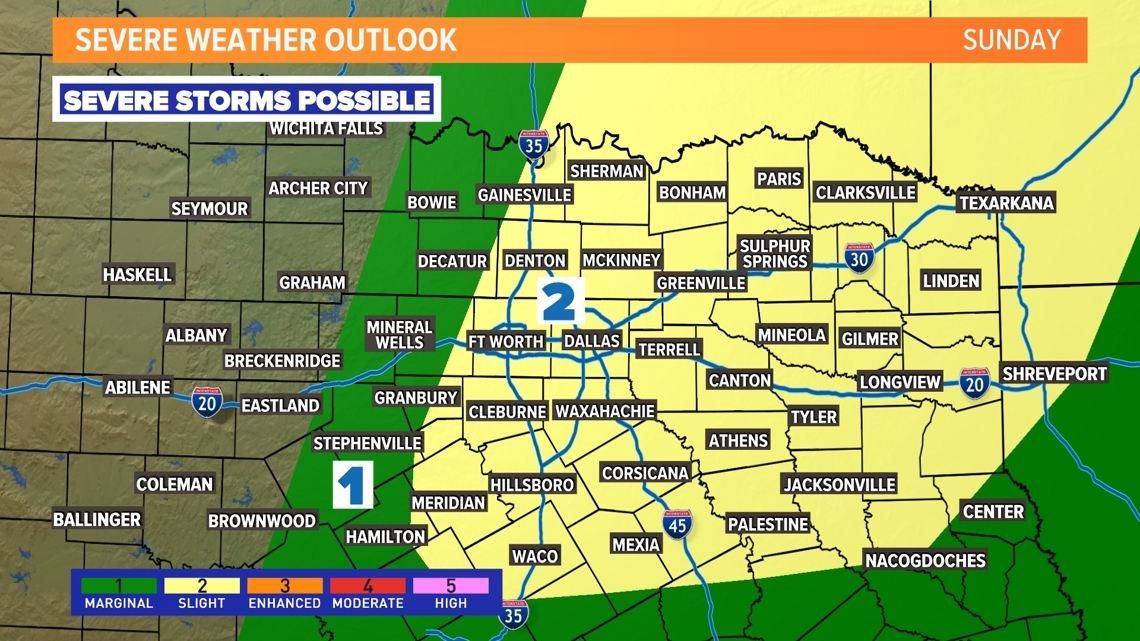
- Severe storms possible each day through the weekend
Live Updates:
6:09 p.m. Another tornado warning has been issued for Van Zandt County -- this one until 6:30 p.m.
5:44 p.m. All tornado and thunderstorm warnings across North Texas have expired, although some areas to the southeast of the Metroplex remain under flash flood warning.
4:54 p.m.: Ellis, Hill and Navarro counties are under a flash flood warning until 6:30 p.m.
4:50 p.m.: The Tornado Warning has been extended until 5:15 p.m. for Van Zandt County.
4:25 p.m.: A Tornado Warning has been issued for Kaufman and Van Zandt counties until 5 p.m.
3:38 p.m.: Navarro, Hill and Ellis counties are under a severe thunderstorm warning until 4:30 p.m.
3:05 p.m.: A Tornado Warning for Hill County has been issued until 3:45 p.m.
3 p.m.: The Tornado Warnings for Ellis, Henderson and Kaufman County have all been cancelled.
2:30 p.m.: Ellis, Henderson and Kaufman County are all under a Tornado Warning until 3:15 p.m.
1:56 p.m.: Ellis is in a Tornado Warning until 2:30 p.m. People who are located within the red box highlighted in the below images should seek shelter immediately. A confirmed tornado is reported along that path.
1:37 p.m.: A new Tornado Warning has been issued for Hill County until 2:15 p.m.
1:30 p.m.: A tornado warning was issued for Navarro County as a confirmed tornado was on Farm Road 744 near Brush Prairie.
10:15 a.m.: A Tornado Watch has been issued for parts of North Texas including DFW until 6 p.m.
Bottom line:
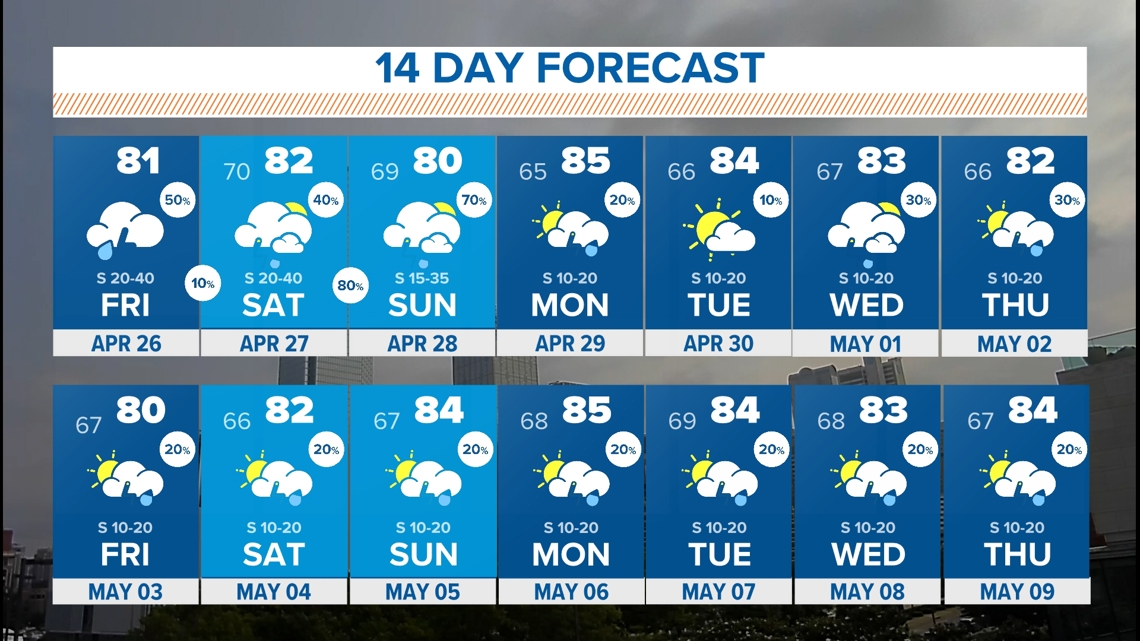
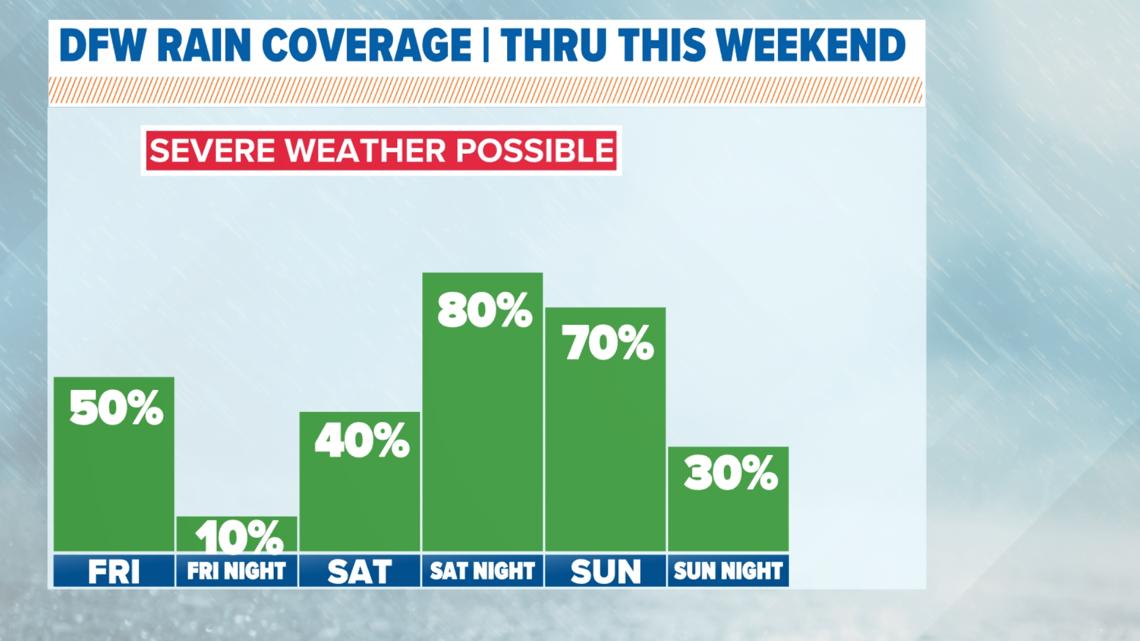
Thunderstorm coverage will vary through the weekend. It won't rain the whole time.
It does look like the most active periods will be Friday close to midday, Saturday afternoon, and Saturday night into Sunday morning.
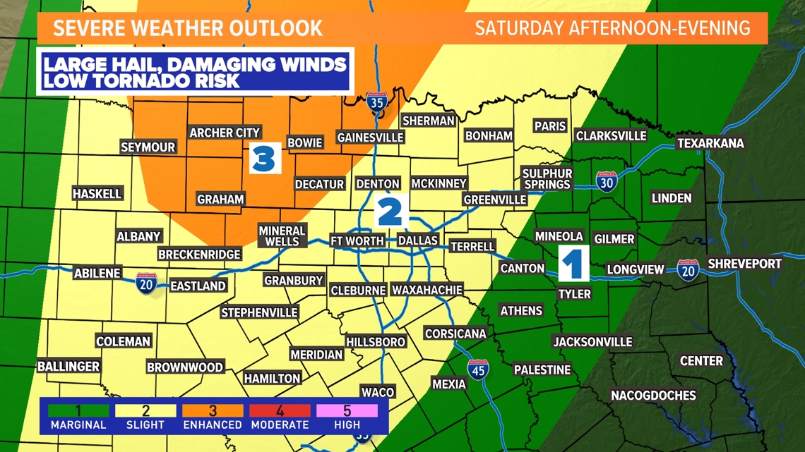
Not everyone will see severe weather, but there is the potential for any storms to turn severe with large hail and damaging winds being the primary risks. The tornado risk is there, but it is low at this time.
At times, there will be a strong cap in place which will limit storm production.

What about the rest of the weekend?
Both days will feature chances for thunderstorms, but it does not look to rain all weekend long. As of now, it looks like the best chances might be later in the day on Saturday, Saturday night, and Sunday morning, but the exact details are far from certain.
Storms could linger Sunday afternoon and evening across eastern North Texas. Once again, some storms could be severe, and if you have plans this weekend make sure to stay weather-aware!


Timeline
Here's a rough guide of what to expect timing-wise as we go through the weekend.
14-Day Forecast